


Atlas Mountains Map and Elevation Guide: From Desert to Snow Peaks
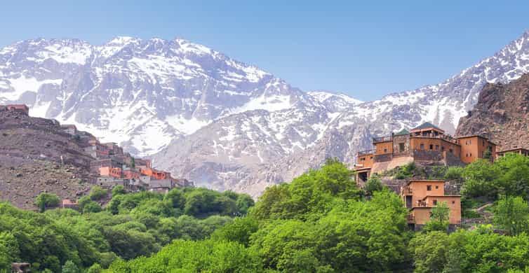
The Atlas Mountains stretch across North Africa, forming one of the continent's most dramatic natural landscapes. Spanning Morocco, Algeria, and Tunisia, this mountain system creates a striking contrast between arid deserts, fertile valleys, dense cedar forests, and snow-covered summits.
Whether you are planning a hiking adventure, studying the region's geography, or simply exploring from home, an Atlas Mountains map provides valuable insight into the range's vast terrain and changing elevations.
Understanding the geography of the Atlas Mountains helps travelers appreciate how these peaks shape the climate, wildlife, and culture of North Africa. This guide explains the mountain range's location, elevation zones, and the remarkable transition from desert plains to snowy mountaintops.
Understanding the Atlas Mountains
The Atlas Mountains extend for approximately 2,500 kilometers (1,550 miles), separating the Mediterranean coastline from the Sahara Desert. This natural barrier influences weather patterns, creating greener landscapes on the northern side while limiting moisture reaching the southern deserts.
The range consists of several distinct mountain systems, each with unique characteristics:
· High Atlas
· Middle Atlas
· Anti-Atlas
· Saharan Atlas
· Tell Atlas
An Atlas Mountains map helps visualize how these interconnected ranges stretch across three countries while offering dramatically different environments.
Where Are the Atlas Mountains Located?
The mountains begin in southwestern Morocco and continue northeast through Algeria before reaching Tunisia. Their location makes them one of Africa's most significant mountain systems.
The map of the Atlas Mountains in Africa clearly shows how the range separates the Sahara Desert from the Mediterranean region. This geographical position plays a vital role in agriculture, water supply, and biodiversity throughout North Africa.
Major regions include:
· High Atlas (Morocco): Home to the highest peaks.
· Middle Atlas (Morocco): Known for forests and lakes.
· Anti-Atlas (Southern Morocco): Older mountains with rocky landscapes.
· Tell Atlas (Algeria and Tunisia): Close to the Mediterranean coast.
· Saharan Atlas (Algeria): Marks the northern edge of the Sahara.
Elevation Zones: From Desert Floor to Snow Peaks
One of the most fascinating aspects of the Atlas Mountains is the rapid change in elevation. Travelers can move from desert environments to snow-covered mountains within just a few hours.
Low Elevation (200–800 meters)
The foothills near the Sahara are warm and dry. Vegetation is sparse, consisting mainly of shrubs and drought-resistant plants. Small villages often rely on oasis farming supported by underground water sources.
Mid Elevation (800–2,000 meters)
As elevation increases, temperatures become cooler and rainfall becomes more common. Olive groves, orchards, cedar forests, and fertile valleys dominate these landscapes.
Many traditional Berber communities have established villages throughout these mountain slopes because of reliable water supplies and productive farmland.
High Elevation (2,000–4,167 meters)
Above 2,000 meters, alpine conditions begin to appear. Winters bring heavy snowfall, while summers remain pleasantly cool compared to surrounding lowlands.
Mount Toubkal, rising to 4,167 meters (13,671 feet), is the tallest peak in North Africa. Snow often remains visible for much of the year despite Morocco's generally warm climate.
Reading an Atlas Mountains Map
An atlas mountains map displays much more than mountain locations. It helps readers understand the region's geography and travel routes.
Important features commonly shown include:
· Major mountain ranges
· Elevation contours
· National parks
· Rivers and valleys
· Mountain passes
· Hiking trails
· Nearby cities
· Desert boundaries
These details help visitors plan road trips, trekking routes, and sightseeing adventures while understanding how terrain changes across the region.
Climate Changes with Elevation
The Atlas Mountains create several climate zones because elevation strongly affects temperature and rainfall.
Lower elevations remain hot and dry throughout most of the year. Higher regions receive considerably more rainfall, supporting forests and rivers that feed nearby agricultural areas.
Winter transforms the highest peaks into snowy landscapes, attracting hikers, photographers, and winter sports enthusiasts.
The map of the Atlas Mountains in Africa highlights why such dramatic climate differences exist across relatively short distances.
Rivers and Valleys
Snowmelt from the Atlas Mountains supplies water to numerous rivers that sustain millions of people across North Africa.
Important river valleys support:
· Fruit orchards
· Vineyards
· Olive cultivation
· Traditional farming
· Local communities
Without the mountain snowpack and seasonal rainfall, much of southern Morocco would be significantly drier.
Wildlife Across Different Elevations
The changing elevation creates habitats for a wide variety of wildlife.
Lower elevations are home to reptiles, desert foxes, and hardy bird species adapted to arid environments.
Forested middle elevations provide habitat for:
· Barbary macaques
· Wild boar
· Foxes
· Eagles
· Numerous migratory birds
Higher alpine regions support mountain sheep, specialized plants, and unique ecosystems adapted to colder temperatures.
Popular Destinations Along the Range
Several destinations allow visitors to experience the Atlas Mountains from different perspectives.
High Atlas
Ideal for trekking, climbing, and reaching Mount Toubkal.
Middle Atlas
Known for cedar forests, lakes, waterfalls, and wildlife viewing.
Anti-Atlas
Offers dramatic rock formations, quiet villages, and desert scenery.
Dades Valley
Famous for winding roads, impressive gorges, and colorful cliffs.
Ourika Valley
A popular day-trip destination featuring rivers, waterfalls, and traditional Berber settlements.
Why Maps Matter for Travelers
Whether hiking or driving, understanding the terrain makes travel much safer and more enjoyable.
A detailed atlas mountains map helps visitors:
· Estimate travel times
· Identify mountain passes
· Locate villages
· Plan hiking routes
· Understand elevation changes
· Find scenic viewpoints
Because mountain roads often twist through steep valleys, straight-line distances rarely reflect actual travel time.
Best Seasons to Explore
Each season offers a different experience.
Spring (March–May) brings blooming wildflowers, flowing rivers, and comfortable hiking temperatures.
Summer (June–August) is ideal for escaping the intense desert heat by visiting higher elevations.
Autumn (September–November) offers mild weather, colorful landscapes, and excellent trekking conditions.
Winter (December–February) transforms the High Atlas into a snowy destination suitable for winter sports and photography.
Geography's Influence on Local Culture
The mountains have shaped the traditions of Berber communities for thousands of years.
Villages were built near rivers and fertile valleys, while mountain passes became important trade routes connecting the Sahara with Mediterranean cities.
Even today, many communities maintain traditional architecture, farming techniques, and crafts that reflect centuries of adaptation to mountain life.
Viewing the map of the atlas mountains in africa helps explain why settlements developed where reliable water and fertile land were available despite the surrounding arid landscapes.
Conclusion
The Atlas Mountains represent one of North Africa's most extraordinary geographical features, connecting lush valleys, dense forests, rugged cliffs, and snow-covered peaks within a single mountain system. An atlas mountains map provides an essential guide to understanding these dramatic elevation changes and the diverse environments they create.
From the Sahara's edge to Mount Toubkal's summit, the range offers an unforgettable journey through some of Africa's most varied landscapes. Whether you're planning an adventure or expanding your geographical knowledge, exploring the map of the atlas mountains in africa reveals why this remarkable mountain chain continues to captivate travelers, hikers, and nature enthusiasts from around the world.
Κατηγορίες
Διαβάζω περισσότερα
Moving to a new home or office should be an exciting experience, not a stressful one. Choosing the best San Francisco movers ensures that every stage of your relocation is handled with professionalism, efficiency, and care. Whether you are relocating across the city, moving to another part of California, or planning a long-distance move, working with an experienced moving company in San...

Buy Old Facebook Account Buy an old Facebook account can be a strategic move for those seeking to enhance their online presence. These accounts often come with established friendships, post histories, and credibility that new profiles simply lack. When you purchase an old account, you gain immediate access to potential followers who may already resonate with your content or brand. This can save...

In today’s competitive digital market, businesses are constantly searching for ways to improve their online presence and generate more leads. Choosing a seo services company in navi mumbai can be a game-changer, especially for local businesses aiming to target customers in specific areas. A company like Wayforweb Company understands the local market, customer behavior, and advanced AI...

Buy Telegram Accounts Buy Telegram accounts can be a game-changer for businesses looking to expand their digital footprint. With millions of active users, Telegram offers an unparalleled platform for marketing and audience engagement. 🚬🍁🌍🐼🤰🏽24 Hours Reply/Contact 🚬🍁🌍🐼🤰🏽➤Discord:getpvasmm 🚬🍁🌍🐼🤰🏽➤Telegram: @getpvasmm 🚬🍁🌍🐼🤰🏽➤WhatsApp: + 1 (830) 739-8217 VISIT OUR SITE:...

Choosing the right NEET coaching institute is one of the most important decisions a parent will ever make for their child. With the competition for medical seats increasing every year, the pressure on students — and parents — is immense. NEET is not just an exam; it is a life-shaping milestone that demands the right guidance, environment, and long-term academic strategy. South Delhi...